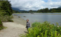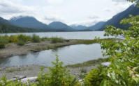


Vancouver Island is home to one of the world's most diverse
ecosystems including rainforest, marshes, meadows, beaches,
mountains, oceans, rivers and lakes, making it a premier location for
whale watching, bird and bear watching, salmon and trout fishing.
With the Pacific Rim National Park and Strathcona Provincial Park it
is a wonderfull place for hiking and watching nature. The island is
bisected, north to south, by the Beaufort Mountain Range. The
beauty and tranquility of this region is it’s largest attraction.
Vancouver Island herbergt een van ‘s werelds meest diverse
ecosystemen zoals regenwoud, moerassen, weiden, stranden,
bergen, de oceaan, rivieren en meren. Dit maakt het een belangrijke
lokatie voor het bekijken van walvissen, vogels en beren en er kan
gevist worden op forel en zalm. Met het Pacific Rim National Park en
Strathcona Provincial Park is het er prachtig om te wandelen en de
natuur te observeren. Het eiland wordt van noord naar zuid
opgedeeld door de Beaufort bergketen. De schoonheid en rust van
deze regio is zijn grootste attractie.
Wild Pacific Trail - Pacific Rim National Park
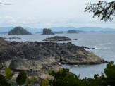
In Ucluelet we followed a part of the Wild Pacific Trail along a
beautiful part of the coast on the Pacific Ocean with views on the
Broken Island Group. We saw our first pair of Bald Eagles here on a
small island just off the shoreline.
Near Tofino we walked several trails in the Pacific Rim National Park
we walked through fantastic rainforest and walked on Long Beach
and Schooner Cove and looked at Wickaninnish Beach. Here too we
encountered a Bald Eagle.
In Ucluelet volgden we een deel van de Wild Pacific Trail langs een
prachtig deel van de kust aan de Pacifische Ocaan met zicht op de
Broken Island Group. Hier zagen we ons eerste paar Bald Eagles
(Amerikaanse Adelaar) op een klein eiland voor de kustlijn.
Bij Tofino wandelden we in het Pacific Rim Natinal Park over
verschillende paden door het fantastische regenwoud en over Long
Beach en Schooner Cove en keken we naar Wickaninnish Beach.
Ook hier zagen we een Bald Eagle.
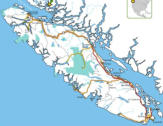
From Victoria
we drove
Highway 14 to
Sooke where
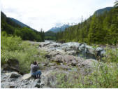
we looked at
Sooke Pot-
holes Regional
Park (not
caves but
washed out holes in the
riverbed), We passed River
Jordan to arrive in Port Renfrew.
We crossed the San Juan river
and followed the new Pacific
Circle Route to Lake Cowichan.
We returned to Highway 1 up
north to Nainamo where stayed
at the Living Forest Oceanside
Campground.
Van Victoria reden we over
Highway 14 naar Sooke waar we
een kijkje namen in Sooke
Potholes Regional Park (geen
grotten maar kolkgaten in de
rivierbedding). We passeerden
River Jordan en kwamen in Port
Renfrew. We staken de San
Juan rivier over en volgden de
nieuwe Pacific Circle Route naar
Lake Cowichan. We keerden
terug naar Highway 1 en reden
noordwaarts naar Nainamo waar
we op de Living Forest
Oceanside Campground
overnachtten.
From Nainamo we drove Hwy 4
to the west across the McKenzie
Range to Ucluelet. A nice trip
through a forested mountain
scenery with rivers and lakes.
Van Nainamo reden we over
Hwy 4 westwaarts over de
McKenzie Range naar Ucluelet.
Een mooie rit door een bosrijk
berglandschap met rivieren en
meren.
From Ucluelet we went back east
on Highway 4 to Qualicum Beach.
We followed Highway 19A north
along the coast to Campbell River.
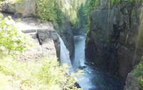
Just east of Elkfalls Provincial Park
we stayed at Parkside Camp-
ground. We walked 2 km to the
Park next morning and followed
the trail to the fall. In the afternoon
we went further west to Strathcona
Provincial Park and took the road
along Buttle Lake. We walked the
Karst and Shepherd trail.
Van Ucluelet reden weer terug
naar het oosten over Highway 4
naar Qualicum Beach. We volgden
Highway 19A noordelijk langs de
kust naar Campbell River. We
verbleven op Parkside Camp-
ground net ten oosten van Elkfalls
Provincial Park. De volgende
ochtend wandelden we de 2 km
naar het Park en volgden het pad
naar de waterval. ‘s Middags reden
we verder naar het westen naar
Strathcona Provincial Park en
namen de weg langs Butlle Lake.
We liepen hier over de Karst en de
Shepherds Trail.
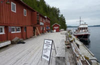
On our way to Port Hardy we
visited the nice village of Telegraph
Cove were we also met our first
Black Bear.
Op weg naar Port Hardy
bezochten we het mooie plaatsje
Telegraph Cove waar we ook onze
eerste Zwarte Beer tegen kwamen.


Ucluelet - Campbell River

Victoria - Nanaimo
Canada’s top Island - Het top eiland van Canada


Nanaimo - Ucluelet


Campbell River - Port Hardy


